Highlights
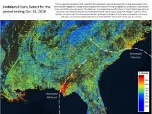 |
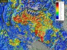
Hurricane Michael storms Florida's panhandleThe destructive impacts of Category 4 Hurricane Michael on the forests of northwest Florida were captured by ForWarn II's routinely produced Early Detect product one week after the event. The stark pattern of greatest damage in red and orange consists of a 50 km-wide swath that stretches from near the track of the hurricane's eye to the Apalachicola River which likely had reduced greenness from both wind damage and flooding. This damage to forests crosses the entire Florida panhandle into... (read more) |
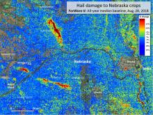 |
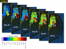
ForWarn II maps hail damage to Midwestern cropsForWarn's all-lands approach to monitoring provides valuable insights into crop damage caused by summer storms. In July and August of 2018, hail storms struck eastern Nebraska causing severe damage to corn and soy. Remote sensing provides an invaluable way to track severe weather's effect on agricultural production, especially when it can be delivered soon after the event. Most storm reports of hail, for example, do not result in detectable change, suggesting that they are of limited... (read more) |
 |
Hurricane Florence soaks the SouthHurricane impacts to forests can vary greatly depending on the qualities of the storm. Hurricane Florence stood out for its slow speed and heavy rainfall to the Carolinas, while Hurricane Michael, that crossed Florida's panhandle just a few weeks later in 2018, was a powerful wind-event that passed relatively quickly. ForWarn II's near-real-time capabilities reveal the initial storm effects, then in concert with higher resolution imagery and ancillary data assessments can discriminate among... (read more) |
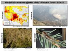 |
Assessing defoliation in the Boise National ForestForWarn’s ability to accurately map defoliation comes from the high temporal frequency of the source imagery (MODIS). With any change detection, multiple disturbances are often at work in the same landscape at the same time, so careful assessment requires consideration of other stressors or disturbances. In the Boise National Forest, defoliation from the spruce budworm and large wildfire have been recurring every year. Recently, a periodic eruption of the Douglas fir tussock moth has... (read more) |
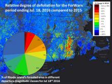 |
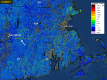
Monitoring the state of Rhode Island's forestsRemote sensing technologies provide an increasingly efficient way to monitor large tracts of forest canopy conditions in near-real-time and seasonally. Observational systems, such as ForWarn's MODIS-based product line, provide a continuous weekly stream of observational data that can be readily processed in ways that are useful for summary reports on changing forest conditions. Remote sensing approaches to regional monitoring are particularly powerful when they use consistent measures,... (read more) |
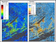 |
Tracking Gypsy Moth emergence and severity with magnitude and durationRemote sensing is adept at identifying and qualifying many forest disturbances, but there remains a substantial need to further quantify actual impacts in many cases. Traditionally, vegetation change-detection approaches, such as that used by ForWarn, identify and measure disturbance severity as the magnitude of change of some measure of reflected light between two dates or periods. ForWarn tracks the percent change in NDVI relative the prior year or years, with this index falling or rising... (read more) |
 |
Defoliation in NC's Roanoke River Bottomland ForestsThe Forest Tent Caterpillar (Malacosoma disstria) is a widespread native defoliator of deciduous forests in the Eastern US. While host trees differ regionally, the insect prefers sweet gum (Liquidambar styraciflua), tupelo gum, black gum (Nyssa spp.) and species of oak (Quercus spp.) in the bottomland forests of North Carolina's Coastal Plain. The larvae hatch in early spring as the tree buds swell, then larvae defoliate emerging and growing leaves in April and early May. After a few... (read more) |
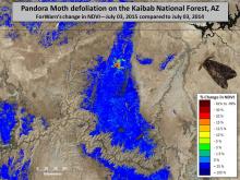 |
Pandora Moth defoliation returns to the KaibabThe Pandora Moth (Coloradia pandora) is a native defoliator of ponderosa, Jeffrey and lodgepole pine trees of the Western US. During most years, populations and defoliation is minor, but periodic outbreaks cause widespread defoliation (Speer and others 2001). The outbreak shown here in Arizona's Kaibab National Forest first caused significant defoliation in June-July of 2013 and defoliating caterpillars have now returned in 2015. One of the more peculiar aspects of outbreaks is that... (read more) |
 |
Mapping the urban phenological footprintUrban areas are renowned for their admixture of species and vegetation types that can change from one parcel to the next. Yards and woodland parks intermix with road medians--all of which may be dominated by an irregular mix of native and exotic trees, shrubs, herbs and grasses. In cities, the vegetation of nearly every block is compositionally complex. These species green up at different times and at different rates. Because of this, it can be difficult to decide when spring occurs... (read more) |
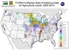 |
The typical start of greenup on agricultural landsUnderstanding the normal start of greenup for croplands is important because it provides a baseline to compare year to year conditions. The date of greenup for agricultural lands varies based on year-to-year climate factors, the unique responses of the specific crop or vegetation type planted, and farmers' management practices. For areas that need to be planted in the spring, wet late winters can delay planting. Cool springs can delay growth. Either can potentially influence seasonal growth... (read more) |
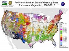 |
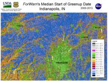
The typical start of greenup in natural vegetationThe start of the annual growing season is among the most important climate-sensitive measures that Land Surface Phenology (LSP) products like ForWarn can provide. Warm temperatures can accelerate bud burst, and this can increase exposure to damaging spring frosts, as it did across the Southeastern US in 2007 and 2012. In natural areas, the timing of spring greenup can affect growing season duration and productivity. It can also affect the risk and impacts of disturbances, such as those from... (read more) |
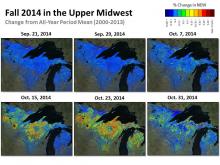 |
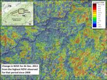
Autumnal Hail and Early Browndown in the Upper MidwestIt can be challenging to detect disturbances during seasonal periods of transition such as Fall or Spring in the eastern deciduous forest. The baseline conditions we use to compare with current conditions harbor a lot of normal variation that results from the onset and progression of cold temperatures. In the upper Midwest, Fall is typically reflected by a gradual drop in NDVI during September, then a more rapid decline in October. By the beginning of November during most years, this decline... (read more) |
 |
Coastal pocosins respond to hurricanes and fireCoastal forests and shrublands can be vulnerable to climate-associated disturbances such as the strong winds and storm surges associated with hurricanes. Because of its extension into the Atlantic, eastern North Carolina is especially vulnerable to such storms, having been hit by several hurricanes during the MODIS period of record (i.e., since 2000). In 2014, Hurricane Arthur struck causing relatively minor damage to forests compared to two earlier events, namely 2003's Hurricane Isabel and... (read more) |
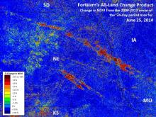 |
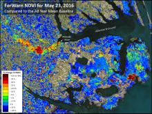
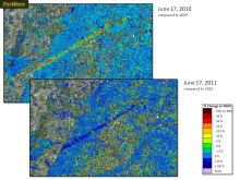
Massive hailstorm destroys Midwestern cropsDuring the first week of June 2014, hail caused significant damage to corn and soybean fields in eastern Nebraska and western Iowa. By June 9th, ForWarn's all-lands product was beginning to show the losses that these storms inflicted across multiple counties despite later than average crop growth in May, and when ForWarn's next product was produced for June 17th, the losses from hail were clearly visible. These maps were made by comparing current NDVI conditions to the all-year mean value... (read more) |
 |
Hemlock death transforms Appalachian forestsAcross the Southern Appalachians, Eastern Hemlock has long created an important ecological niche. As these trees are evergreen, they provide year-long cover for wildlife and they cool riparian areas where they tend to grow. Since the mid 2000s, these forests have been in decline due to a lethal non-native insect known as the Hemlock Woolly Adelgid. Like its kin that devastated Fraser Fir forests at higher elevations during the 1960s and 1970s, the Hemlock Woolly Adelgid has been... (read more) |
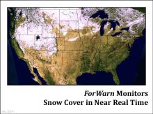 |
Monitoring snow cover in near real timeForWarn's true color product is produced every 8 days at 1km resolution to provide a quality control for ForWarn's disturbance maps. Clouds and snow cover that persists for the entire 24-day MODIS collection window can create the appearance of vegetation disturbance, when it is not. In addition, these true color images show variation in vegetation greenness seasonally and among years. This true color product reveals how snow cover changes over time, and this is particularly... (read more) |
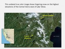 |
Snowpack drives greenup in the SierraYear to year variation in climate has been extreme in California's Sierra Nevada. In particular, low winter snowpack raises concerns about municipal water supplies as reservoirs are fed by spring meltwater. However, low winter snow cover has implications for the region's forests as well. Less snow (and warmer temperatures) often mean an earlier onset of spring and more extended and dryer summer than would otherwise occur. With climate change, warming temperatures are likely to bring earlier... (read more) |
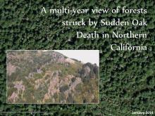 |
A multi-year view of Sudden Oak DeathSudden Oak Death (SOD) is a disease caused by the new pathogen Phytophthora ramorum (Frankel and others, 2013). This spore-producing water mold was first observed when tanoak trees began dying during the mid 1990s in California’s Marin and Santa Cruz Counties. SOD is now known to infect dozens of other species--hosts that help spread the disease--but they do not always succumb. While the SOD pathogen has been detected in nurseries throughout much of the US and in Europe the epicenter of this... (read more) |
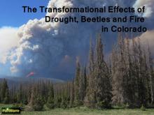 |
Drought, beetles and fire in ColoradoSince 2004, southwestern Colorado's Englemann spruce forests have experienced a severe outbreak of spruce beetles (Dendroctonus rufipennis). Such outbreaks occur episodically, multiple times per century (Anderson et al. 2010). Early research in northern Colorado linked a prior outbreak that occurred in the 1940s and 1950s to wind damaged trees that favored growth in the population of the spruce beetle. More recent research suggests that while local factors may still be important, outbreaks... (read more) |
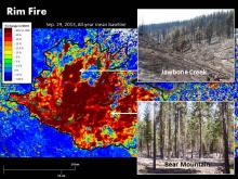 |
Tracking the historic Rim FireThe 2013 Rim Fire burned over a quarter million acres of California's Sierra Nevada, including a portion of the Stanislaus National Forest and Yosemite National Park. It started in mid-August as an illegal campfire after an unusually dry winter and spring. A lower-than-average snowpack melted early, signaling that a hazardous fire season lay ahead. That early season dryness contributed to the below-average productivity in the foothills as shown on ForWarn's June departure map. Once ignited,... (read more) |
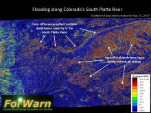 |
ForWarn detects early effects of Colorado floodingIn early September of 2013, unusually heavy rain resulted in catastrophic flooding across Colorado’s Front Range and downstream along the South Platte River. Rainfall exceeded 20 inches northwest of Denver, which is close to the average rainfall for that area during an entire year. Flash floods led to massive evacuations, a severe loss of public and private property, and loss of human life. Oil and gas lines and tanks were damaged, causing the release of thousands of gallons of pollutants... (read more) |
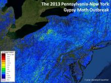 |
Monitoring Gypsy Moth defoliation in near real timeBy late 2012, forest health monitors in western New York and Pennsylvania knew that they were about to experience a severe outbreak of the non-native Gypsy Moth. Surveys showed an unusually high density of egg masses on the branches and trunks of trees, but neither egg densities, nor the distribution of primary host trees are ever perfectly known across the forest, so translating general predictions to a map remains a challenge. Using the best information available, forest managers... (read more) |
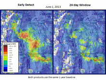 |
Early Detect captures hailstorm in near real timeForWarn's standard calculation of the current state of vegetation is based on the maximum NDVI value observed for each 24 day period. This standardized window is needed to minimize the chance that clouds or other atmospheric effects will cause misleading results in the change product. For many periods and in some portions of the US, a much shorter window is sometimes possible. ForWarn's new Early Detect product uses the most recent clear view to capture change as soon as possible, even... (read more) |
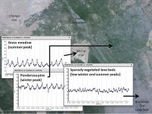 |
Phenology is key for vegetation monitoringLand managers in the West seek to efficiently monitor their forests and rangelands, particularly after wildfire. ForWarn's high frequency record of the Normalized Difference Vegetation Index (NDVI) provides a coarse filter means to accomplish this using two measures. First, the mean NDVI varies with vegetation composition and density such that bare ground has a low NDVI, grass is higher, shrubs and open forest stands are higher still, and dense forests are highest. Second, variation in the... (read more) |
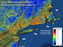 |
Hurricane Sandy strikes Northeastern forestsHurricane Sandy, one of the most damaging hurricanes to strike the United States, tested the monitoring ability of the ForWarn system. Detecting any disturbance is difficult during the spring and fall because vegetation is actively changing due to normal seasonal dynamics. Normal variation in weather can advance or retard the progress of these transitions by a week or more making it hard to know if observed change is from an early fall or an event. Hurricane Sandy struck the North Atlantic... (read more) |
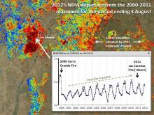 |
Reburning the Jemez MountainsForWarn's MODIS satellite-based products go back to 2000, and this allows us to observe the effects of wildfire and recovery since early in the decade. In exceptional cases, areas can reburn and this provides us with long-term monitoring insights into how vegetation is affected by a return in frequent fire. A portion of Santa Fe National Forest near Los Alamos, NM is one such area that has been reburned by wildfire in recent years. Portions of the 2000 Cerro Grande Fire were reburned in 2011... (read more) |
 |
Hail pellets a city watershedThe spring of 2012 was exceptional across much of the eastern US because it occurred weeks earlier than normal. Yet some forests also experienced strong spring hail storms that left leaves in tatters and set spring growth back. Forwarn successfully captured this localized hail event that struck the watershed that the City of Asheville uses as their primary water supply in early May. At the time, some was observed from lower elevation vantage points, but the remoteness of this area affected... (read more) |
 |
Multiple baselines reveal short and long-term changeForWarn's ability to capture short and long-term change is shown by this animated image pair that provides two different temporal contexts for the same date in May of 2012. The "all year" baseline shows change since 2000. Note the patchy forest loss from strip mines in eastern Kentucky and West Virginia. Twin tornadoes also show up, and these occurred in March 2012. As expected, they also appear on the second image that shows change since May 2011, but most of the strip mine activity does... (read more) |
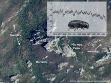 |
The browning of the Black HillsOver the last 15 years, Mountain Pine Beetles have killed large tracks of ponderosa pine across the Black Hills of South Dakota. Beetles thrive with continuous stands of dense trees, and decades of fire exclusion have led to that landscape and stand-level condition. That favorable habitat may help explain why the current epidemic of this native insect has been so severe. In this summer 2010 aerial photograph, the patchy structure of recent and older tree mortality shows up well around Harney... (read more) |
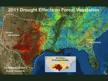 |
The exceptional drought of 2011Across Texas, 2011 will long be remembered as the year that the trees died. After over a century of weather station data, 2011 saw record breaking drought across New Mexico, Texas, Oklahoma and Louisiana; but it was west Texas in particular, that suffered the greatest and most persistent loss of greenness from drought and the numerous associated fires. In this ForWarn image for late September 2011, there are centers of drought in and around Texas and farther to the Southeast centered on... (read more) |
 |
Defoliation on the bayouSpring often brings defoliating insects to the forests of Louisiana. In this image from early May 2010, defoliations from forest tent caterpillars and baldcypress leafrollers create an erupting "measles-like" pattern. Note the subtle differences in severity outward from the centers of several of the blotches. The insets show the baldcypress leafroller (left: photo by Gerald Lenhard, LSU: bugwood.com 0014219) and the forest tent caterpillar (right; photo by Stephen Katovich, USFS; bugwood.com... (read more) |
 |
Lake-effect snow affects spring greenupThis late April 2010 image shows a large anomaly just east of Lake Ontario on the Tug Hill Plateau of New York. A less severe area of departure from the prior year’s condition occurs to the east. Based on weather records, the 2009-10 winter at Lake Pleasant, just east of Tug Hill, was 4.5 degrees F warmer than it was during the prior winter. Continued warmth into spring explains why so much of the northeast is strongly blue in this image. Somewhat ironically, warmer winter temperatures... (read more) |
 |
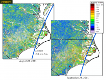
A rare outbreak of pine butterfliesOutbreaks of the defoliating pine butterfly are rare. In eastern Oregon, outbreaks occurred in 1908-11, 1940-43, 1982 and from 2008 to 2011. Sometimes defoliations can lead to mass mortality of ponderosa pine—the primary host, but not always. This current outbreak on the Malheur National Forest is largely responsible for the forest change anomalies in ForWarn for September 29, 2011 compared to 2010. According to aerial detection surveys, areas inside and outside these pine butterfly areas... (read more) |
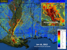 |
High water soaks the AtchafalayaThe Atchafalaya basin's forests thrive with seasonal flooding, yet high water is normally a spring phenomenon there. During the past month, unusually high water levels have inundated wetlands and forests along and near the Mississippi River basin. From space, floodwaters appear to decrease existing vegetation, as water masks low lying plant cover. According to the USGS, river discharge at Morgan City, Louisiana was 145,000 ft3/sec on January 16, 2012 compared to 84,000 ft3/sec the prior year... (read more) |
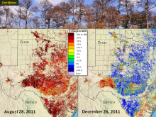 |
Drought takes a toll on Texas treesThe forests of Texas continue to suffer through one of the most extreme droughts on record and a large number of trees have already died. The photo shows mortality in Memorial Park, Houston (Ron Billings, Texas Forest Service). By late August of 2011, the regional change in greenness from the prior year were extreme. Across the map, this decline was caused by the combined effects of drought and fire. By December of 2011, some recovery occurred as shown in blue, but this December condition... (read more) |
 |
Webworms erupt in the AlleghenyThis fall 2011 webworm outbreak in the Hickory Creek Wilderness Area of the Allegheny National Forest, Pennsylvania stands out against the near normal (blue) background that dominated the state in early fall. There were minimal indications of defoliation in mid-August, but clear patterns of severity were clear by mid-September. This anomaly persisted through November, when leaflessness is the normal pre-winter condition for deciduous trees. Recognizing insect defoliations near the end of the... (read more) |
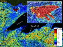 |
Fire and frost hit the Upper MidwestIn September of 2011, the Pagami Creek Fire burned over 92,000 acres in the Boundary Waters Canoe Area Wilderness (BWCAW) of the Superior National Forest, Minnesota Much of this burned at high severity, as indicated on the October forest change image. This was the largest fire to occur in this area since the 1999 blowdown event. The less extreme forest change shown in yellow and orange across northern Wisconsin and Michigan is largely the result of a hard early frost that accelerated the... (read more) |
 |
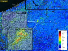
Defoliation in the WenatcheeA sizable portion of the Wenatchee National Forest, Washington shows less vegetational vigor than it did at its peak of the last decade. While such declines in NDVI often result from tree death due to wildfires in the west, no large fire has occurred here as is shown by the distribution of MODIS hotspots (shown as white triangles) between 2000 and 2011. Much of this reduction through September 13, 2011 may have been caused by the cumulative effects of defoliating insects on tree mortality,... (read more) |
 |
Development cuts forests near RaleighSubstantial forest area has fallen to development in the periphery of many urban areas over the last decade. The image below shows deforestation in the periphery of Raleigh, NC as yellow to red anomalies. Blue areas have not changed during the last decade. This reveals that many forested inliers have been converted south and east of downtown, but that large areas have been converted west of the city along the outer highway belt. The large block of unroaded blue northwest of downtown is a... (read more) |
 |
Yazoo tornado recoveryOn April 24, 2010, a lethal F4 tornado struck the forests east of Yazoo City, Mississippi. Within a few weeks the path of the storm and patterns of severity are clearly shown with this comparison of conditions relative to the same time in 2010--the year before the event (top image). After one year of recovery, that same track is shown in dark blue compared to the post-disturbance 1-year baseline. Had the long-term baseline been used for 2011, the path would still be shown as anomalously low... (read more) |
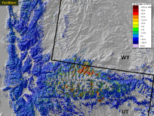 |
Watching pine beetles in the WasatchThis image shows forest change anomalies on the north slope of the Wasatch Range of Utah on September 13, 2011 compared to the prior year. The high elevation zone above treeline is shown as an uncolored area under the words “Wasatch Range”. Most of the region’s forest is blue, meaning it is similar to that of 2010. Just below treeline, the Range’s slopes show a moderate to extreme departure in greenness. In recent years, the north slope in particular, has experienced repeated outbreaks of... (read more) |
 |
Forest loss marks strip minesDeforestation for strip mining is common practice in the coal regions of eastern Kentucky, Virginia and West Virginia. The image below shows areas where forests have been removed for mining over the last decade (left). Using a one-year baseline, it is possible to map areas that are both more and less vegetated on a shorter time scale. This maps where mining activity has been active, where succession or reclamation is taking place. The long term baseline reveals the cumulative effects of this... (read more) |
 |
Hurricane Irene makes landfallThis before-after image pair shows changes associated with Hurricane Irene. Its path is shown by the bold blue line. In the pre-Irene image (left) shades of green and yellow show the effects of drought on vegetation and dark red spots are recent wildfires. Irene brought damaging winds that defoliated trees, but also much needed rain which increased greenness. By the end of September (right) the effects of the storm appear to have reduced vegetational vigor in the hardest hit areas of extreme... (read more) |
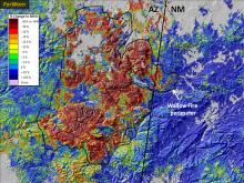 |
Arizona bears the WallowIn June, the Wallow Fire burned over half a million acres in east-central Arizona, much of it on the Apache-Sitgreaves National Forests. A substantial portion of the burn area was of high severity, killing millions of trees outright. Looking south-southwest over the Escudilla Mountain Fire Lookout Tower (upper left), the effects of the high severity fire are clear. This observed severity is consistent with the ForWarn map from July (upper right, shown with 50 percent transparency) that... (read more) |
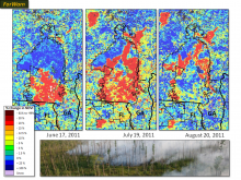 |
Rapid regrowth as the Okefenokee burnsGeorgia’s Okefenokee Swamp National Wildlife Refuge near the Georgia-Florida line burned in 2007 and again in 2011. This rapid recovery of fuels reflects the importance of sprouting vegetation. In the map sequence from the summer of 2011, this resilience is clear. By June 17, wildfire had spread northward through about half the Refuge as shown in red (left). By July 19 (center), fire had progressed north and a new fire became evident northwest of the Refuge. By August 20 (right), vegetation... (read more) |
 |
Monitoring a Pocosin fire and its recoveryThe Pains Bay Fire was started by lightning on May 4, 2011 in the peaty soils of North Carolina’s coastal plain. By the end of June, the fire was contained, but the deep soils continued to smolder for weeks. The white line marks this 45,000 acre fire’s final perimeter. The center of the fire burned with low severity, allowing rapid recovery of herbs, ferns and sprouting woody species by August; yet an outer ring shows a longer lasting departure from prior years. For more information about... (read more) |
 |
Tornado tears through MassachusettsA severe tornado touched down near Springfield, Massachusetts on June 1, 2011, then carved a path through nearly 30 miles of state and private forest. The streak in red show an extreme reduction in growth compared to the prior year’s condition as of mid-June. Many of the trees damaged or destroyed were evergreen conifers that recover slowly. Always remember that many disturbed areas are salvaged after the event, so the ultimate change can involve both the disturbance and subsequent forest... (read more) |
 |
Caterpillars defoliate the Pee DeeAccording to climate data, coastal North and South Carolina were having a mild drought in mid May of 2011. Mean water flow for the Pee Dee River near Pee Dee, SC during the 24-days prior to May 16 was 15.9% below the 2003-2010 average for that time according to USGS statistics (http://waterdata.usgs.gov). These clues suggest that this reduction along the Waccama and Pee Dee Rivers of the Carolinas is not the result of flooding. Aerial detection... (read more) |
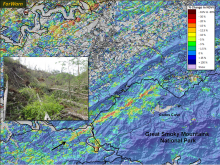 |
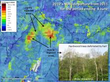
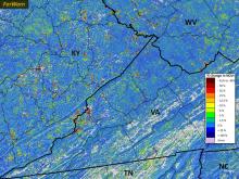
The Great Smoky Mountains tornadoThe April 27, 2011 tornado that hit Great Smoky Mountains National Park in eastern Tennessee was a powerful EF4 storm (its direction is indicated by the black arrow). Wind storms are important natural disturbances for Southern Appalachian forests, and the ecological impacts of this event will be long-lasting as shown in the inset photograph taken by National Park staff soon after the event. Also note the forest disturbance northwest of Maryville. That was the result of strong wind and hail... (read more) |
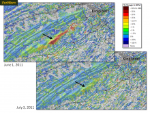 |
Tracking the ephemeral in TennesseeFull-fledged tornadoes are typically well documented, but the massive outbreak of April 2011 also had localized short-term effects that are easily overlooked. This image pair from a month after the storm (top) and two months later (bottom) shows how fast seemingly severe damage can recover, in this case a ridgeline forest southwest of Kingsport, Tennessee. While such ephemeral disturbances from wind and hail can reduce tree productivity and annual growth, it takes high frequency forest... (read more) |
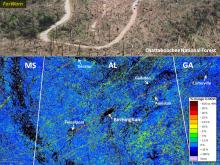 |
Tornadoes scar the SouthForests across northern Mississippi, Alabama and Georgia were hard hit by tornadoes in April, 2011. Tree mortality was often severe for areas in the direct path of these storms as shown in this photo from near Lake Burton in the Chattahoochee National Forest, Georgia (top). In this forest change map from June 1 (bottom), note the parallel, northeastern yellow-red streaks that reveal the location and intensity of these storms. Blue areas have similar growth as in 2010 and were unaffected.... (read more) |