Monitoring the state of Rhode Island's forests
More information about this event
Remote sensing technologies provide an increasingly efficient way to monitor large tracts of forest canopy conditions in near-real-time and seasonally. Observational systems, such as ForWarn's MODIS-based product line, provide a continuous weekly stream of observational data that can be readily processed in ways that are useful for summary reports on changing forest conditions. Remote sensing approaches to regional monitoring are particularly powerful when they use consistent measures, sophisticated baselines for defining "normal", and cross jurisdictional boundaries.
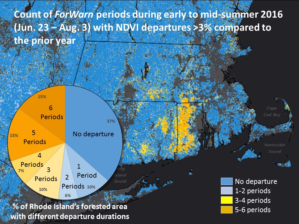
Translating remotely-observed change to actual forest impacts can be difficult. What is mapped as an intense disturbance one month may have partially recovered the next, or even grown worse. The seasonal duration of a disturbance can be quantified with summary products that crunch "big data" down using novel measures, such as the number of weeks that the observed anomaly has persisted.
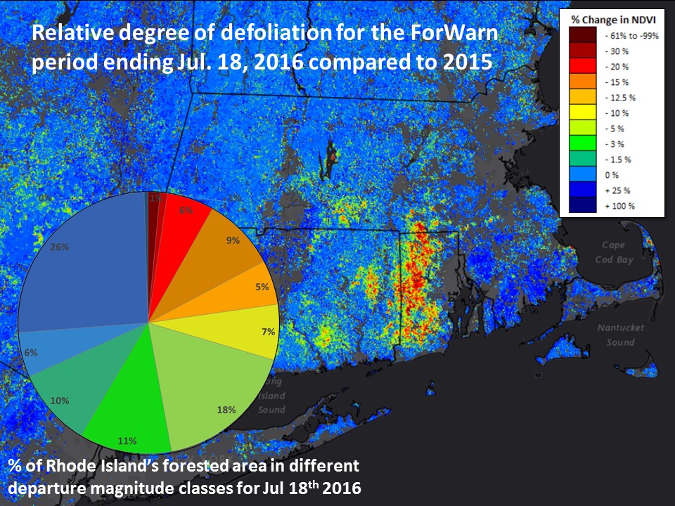
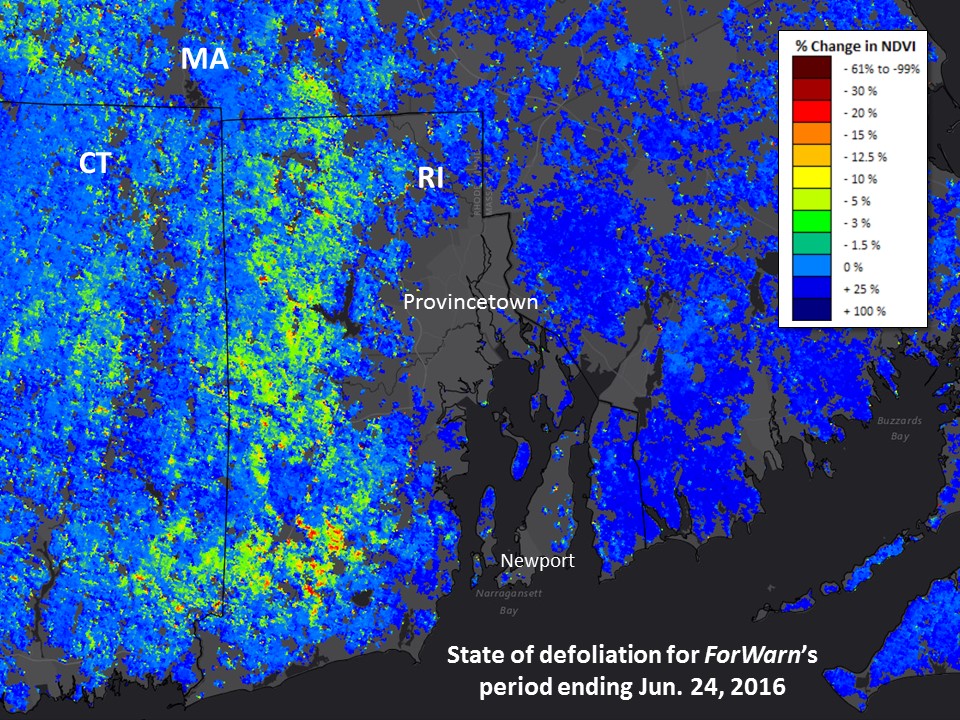
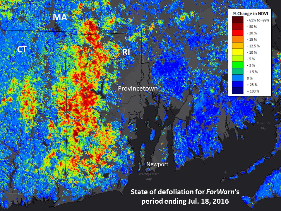
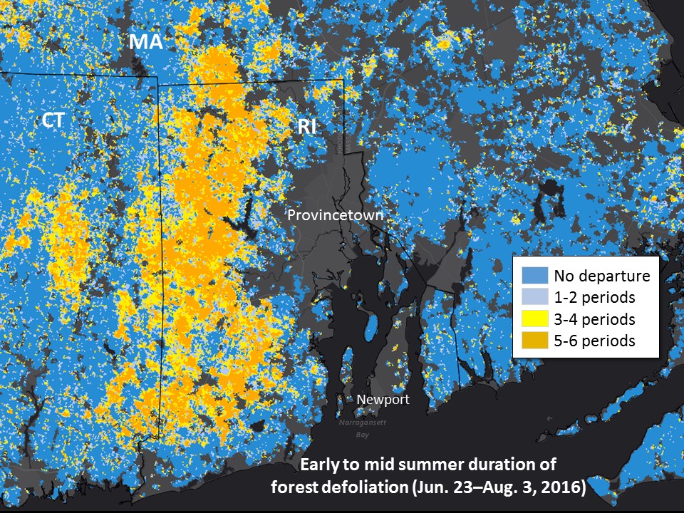
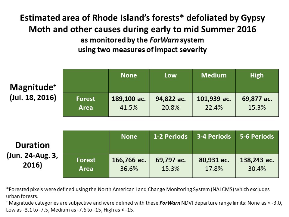
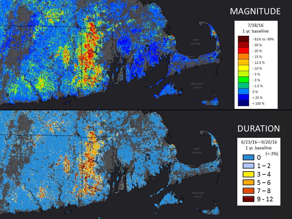
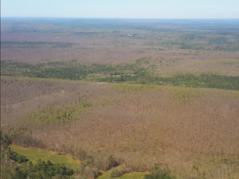
The 2016 Gypsy Moth defoliation in the state of Rhode Island provides a useful illustration of how high frequency remote sensing data streams can take advantage of both the duration and magnitude of canopy declines. While the week-to-week magnitude of change varies, the overall maximum departure appears on July 18, 2016's product. (As ForWarn uses a 24-day moving window, the actual peak defoliation occurred a few weeks earlier). According to extracted summary values for that date's 1-year change product, only 41.5% of the state's non-urban forest was not substantially browner than it had been the year before. However, the duration of this change suggests even more impacts. When conditions over the first six weeks of summer are summarized, only 36.6% of the state's forest was not below normal. This difference is because some defoliated areas had sufficiently recovered by mid July, even as other sites were experiencing more prolonged defoliation. Single period observations can underestimate impacts because peak defoliations may not coincide.
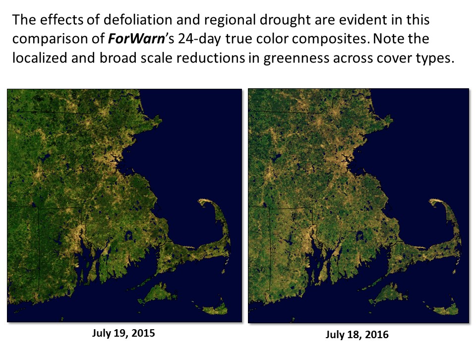
Based on both the high intensity and lasting duration of declines in canopy greenness across a large part of the state, 2016's Gypsy Moth defoliation event in southern New England is particularly severe. Local experts point to recent drought as an aggravating factor for this Gypsy Moth outbreak, and some of this change may be attributable to drought stress, particularly in non-forested areas. Note in the true color image pair that there is a particularly strong reduction in greenness from 2015 to 2016 across agricultural and urban land cover types--that change is likely from drought, and those cover types are masked out in the other change images shown here.
References
Brown, JH, DB Halliwell, WP Gould. 1979. Gypsy Moth defoliation: Impact in Rhode Island forests. Journal of Forestry. 77(1): 30-32(3).
de Beurs, KK and PA Townsend, 2008. Estimating the effect of gypsy moth defoliation using MODIS. Remote Sensing Environment, 112(10):3983-3990.
Earth Observatory, July 15, 2016. Caterpillars take bite out of Rhode Island Forests. http://earthobservatory.nasa.gov/IOTD/view.php?id=88370
Spruce, JP, S Sader, RE Ryan, J Smoot, P Kuper, K Ross, D Pradow, J Russell, G Gasser, R McKellip, W Hargrove. 2011. Assessment of MODIS NDVI time series data products for detecting forest defoliation by gypsy moth outbreaks. Remote Sensing of Environment. 115: 427-437. http://www.treesearch.fs.fed.us/pubs/37274
Ward, JS. 2007. Defoliation and oak mortality in Southern New England. e-Gen. Tech. Rep. SRS-101. USDA Forest Service Southern Research Station. 214-224. http://www.treesearch.fs.fed.us/pubs/27829