Working with Data Layers
By default, the FCAV will open with the most recent one-year baseline forest change product displayed.
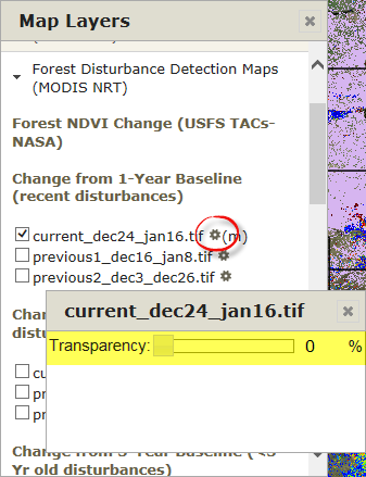
To activate or deactivate a data layer, check the box next to it in the Map Layers window. The FCAV will populate the selected data onto the map instantly, and the layer’s legend will appear in the Map Tools window. You can also quickly clear (or deactivate) a data layer by clicking on its legend in the Map Tools window.
More than one layer can be active at a time, but the other active data layers may appear hidden. The gear icon beside the layer name allows you to adjust the transparency of each layer, so that other activated layers are visible. To do this, click the gear and adjust the slider bar to alter the layer transparency. With this function, the relationships between multiple data layers and the underlying geography can be examined.
There are a total of six different forest change products available every eight days that highlight potential forest disturbances, which are under the Forest NDVI Change category. The different forest change products relate to the length of the baseline and the compositing method used to display percent NDVI departure. They are:
- Change using a 1-Year Baseline (recent disturbances, 1yr or less);
- Early Detect 1-Year Baseline (disturbance resolved in as few as 8-days);
- Change using a 3-Year Baseline (3-year old disturbances);
- Change using a 5-Year Baseline (5-year old disturbances);
- Change using a 10-Year Baseline (10-year old disturbances);
- Change using an All-Year Baseline (all disturbances since 2000);
- Seasonal Progression Departure (by Hargrove);
- The following (2) are located under the "Theme = Seasonal Summaries" drop-down:
- - Prominent disturbance "Duration" (produced at two periods during the summer growing season);
- - Prominent disturbance "Magnitude" (produced once at the end of the summer growing season);
All change products, except the 'Early Detect', are based on a composited mosaic using maximum NDVI value over a 24-day period. The Early Detect uses an 8-day compositing window, because of the limited number of days from which to acquire the maximum NDVI value, these change images may contain more 'nose' associated with clouds, anomalous artifacts and more apparent NDVI decline.
*** VIEW CHANGE PRODUCT DESCRIPTIONS AND BEST USE CASES***
https://drive.google.com/file/d/1hqI014928FMVwo6PjGmxfvx9aombjDY0/view?u...
Types of Data
Below are information and tips for how to use the different types of data available in the FCAV.
Fires
Past and active silvicultural treatments, such as prescribed fire and wildfire, can be observed with layers in the "Fires" tab of the Map Layers window.
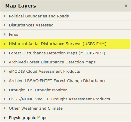
Historical Aerial Disturbance Surveys
If there is no indication of drought, a disturbance activity could be insect related. Use the "Historical Aerial Disturbance Surveys (USFS FHM)” tab to explore previously known locations of activity.
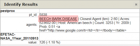
Also, try the "EFETAC Pest Proximity" layer that summarizes all previously known ADS locations. The layer is activated by selecting the the Historical Aerial Disturbance Survey layer bar, selecting one of the ADS layers, and then immediately selecting one of the polygons using the “Identify” icon  . A summarized ADS report is provided containing: 1)the closest disturbance agents in descending probabilities; 2)the closest agent within 75 km; 3)acres of that disturbance; 4) the tree host; 5)number of disturbance polygons in the 75 km radius; 6)year reported; and 7)probability of identification and/or the most likely agent in decreasing orders of probability.
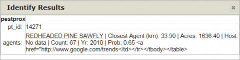
Notice that the disturbance agent reported by the Pest Proximity layer is linked to Google Trends that reports the number and location of Google searches performed on the specific agent. This type of “crowd-sourcing” can be used to gain insight as to the location and timing of specific forest disturbance agents.
eMODIS cloud Assessment Products
If a rapid or sudden NDVI departure is apparent in a single eight-day image compared to the date of the immediately previous image, it could indicate a departure due to clouds or a sensor anomaly. Check the eModis Cloud Assessment products for the same date(s) as the forest change image(s) and look for signs of lighter-toned reflectance and brighter-toned clouds, or look for sensor patterns in the eMODIS true-color composite.
Does the potential disturbance progress in a naturally growing fashion, growing evenly across image dates? This could indicate the onset of drought, insect activity, or possible anthropogenic causes of NDVI change.
Is the NDVI departure area in grass, shrub, agriculture, snow, or on the margins of these land cover types and uses? This could indicate the onset of drought conditions as witnessed by vegetative response to water stress.
The U.S. Drought Monitor is jointly produced by the National Drought Mitigation Center at the University of Nebraska-Lincoln, the United States Department of Agriculture, and the National Oceanic and Atmospheric Administration. Map courtesy of NDMC-UNL.
These products are developed by scientists at the U.S. Geological Survey Earth Resources Observation and Science (EROS) Center in collaboration with the National Drought Mitigation Center and the High Plains Regional Climate Center, with sponsorship from the U.S. Department of Agriculture's Risk Management Agency. VegDRI maps are produced every two weeks and combine satellite-based observations of vegetation conditions with climate and environmental.
Other Weather and Climate
TRMM – Tropical Rainfall Measuring Mission can be retrieved here.
Precipitation Derivatives – Produced by NOAA AWS (Aviation Weather Center), these datasets graphically show the latest short-term observed precipitation across the majority of the National Weather Service Contiguous United States.
Percent of Normal - NOAA PRISM – Parameter elevation Regression on Independent Slopes Model – Parameter elevation Regression on Independent Slopes Model) - National Center for Atmospheric Research Staff (Eds). "The Climate Data Guide: PRISM High-Resolution Spatial Climate Data for the United States: Max/min temp, dewpoint, precipitation." It can be retrieved here.
Climate - NOAA PRISM – Parameter elevation Regression on Independent Slopes Model - Citation: National Center for Atmospheric Research Staff (Eds). "The Climate Data Guide: PRISM High-Resolution Spatial Climate Data for the United States: Max/min temp, dew point, precipitation.
Physiographic Maps
Under the "Physiographic Maps" layer bar there are ancillary data layers that assist in the vetting of potential disturbance, or recovery dynamics. Visit the websites below for more information.
Agriculture: (USDA) Cropland Data Layer
Hydrography: 7 Day Avg. Streamflow
Decadal Change: Statistically mined from the full set of historical MODIS NDVI datasets since 2000, these provisional research datasets depict areas of deciduous and evergreen, thrive and decline, from all disturbance agents and recovery causes.
Phenological (Eco)Regions
Landcover
Forest Type and Forest Group
Forest Biomass
Carbon Stock
National Land Cover Dataset 2006
2001 GAP Landfire
LANDFIRE Fuel Model 40
LANDFIRE Vegetation
Ecoregions
Bailey’s
Omernik
NEON Domains
FWS LCC
Sometimes more recent aerial imagery is available to help vet land cover change, such as from a state’s newer National Agricultural Imagery Program (NAIP) aerial photography. From Landsat, GloVis is a source to download the most recent Landsat imagery to assist in the interpretation of potential disturbances.
Other sources for potential information: