Highlights
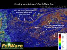 |
ForWarn detects early effects of Colorado floodingIn early September of 2013, unusually heavy rain resulted in catastrophic flooding across Colorado’s Front Range and downstream along the South Platte River. Rainfall exceeded 20 inches northwest of Denver, which is close to the average rainfall for that area during an entire year. Flash floods led to massive evacuations, a severe loss of public and private property, and loss of human life. Oil and gas lines and tanks were damaged, causing the release of thousands of gallons of pollutants... (read more) |
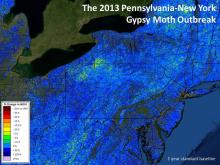 |
Monitoring Gypsy Moth defoliation in near real timeBy late 2012, forest health monitors in western New York and Pennsylvania knew that they were about to experience a severe outbreak of the non-native Gypsy Moth. Surveys showed an unusually high density of egg masses on the branches and trunks of trees, but neither egg densities, nor the distribution of primary host trees are ever perfectly known across the forest, so translating general predictions to a map remains a challenge. Using the best information available, forest managers... (read more) |
 |
Early Detect captures hailstorm in near real timeForWarn's standard calculation of the current state of vegetation is based on the maximum NDVI value observed for each 24 day period. This standardized window is needed to minimize the chance that clouds or other atmospheric effects will cause misleading results in the change product. For many periods and in some portions of the US, a much shorter window is sometimes possible. ForWarn's new Early Detect product uses the most recent clear view to capture change as soon as possible, even... (read more) |
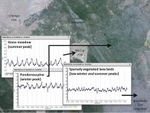 |
Phenology is key for vegetation monitoringLand managers in the West seek to efficiently monitor their forests and rangelands, particularly after wildfire. ForWarn's high frequency record of the Normalized Difference Vegetation Index (NDVI) provides a coarse filter means to accomplish this using two measures. First, the mean NDVI varies with vegetation composition and density such that bare ground has a low NDVI, grass is higher, shrubs and open forest stands are higher still, and dense forests are highest. Second, variation in the... (read more) |
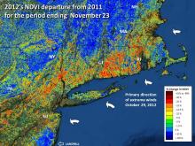 |
Hurricane Sandy strikes Northeastern forestsHurricane Sandy, one of the most damaging hurricanes to strike the United States, tested the monitoring ability of the ForWarn system. Detecting any disturbance is difficult during the spring and fall because vegetation is actively changing due to normal seasonal dynamics. Normal variation in weather can advance or retard the progress of these transitions by a week or more making it hard to know if observed change is from an early fall or an event. Hurricane Sandy struck the North Atlantic... (read more) |
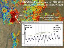 |
Reburning the Jemez MountainsForWarn's MODIS satellite-based products go back to 2000, and this allows us to observe the effects of wildfire and recovery since early in the decade. In exceptional cases, areas can reburn and this provides us with long-term monitoring insights into how vegetation is affected by a return in frequent fire. A portion of Santa Fe National Forest near Los Alamos, NM is one such area that has been reburned by wildfire in recent years. Portions of the 2000 Cerro Grande Fire were reburned in 2011... (read more) |
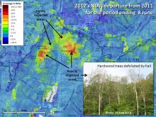 |
Hail pellets a city watershedThe spring of 2012 was exceptional across much of the eastern US because it occurred weeks earlier than normal. Yet some forests also experienced strong spring hail storms that left leaves in tatters and set spring growth back. Forwarn successfully captured this localized hail event that struck the watershed that the City of Asheville uses as their primary water supply in early May. At the time, some was observed from lower elevation vantage points, but the remoteness of this area affected... (read more) |
 |
Multiple baselines reveal short and long-term changeForWarn's ability to capture short and long-term change is shown by this animated image pair that provides two different temporal contexts for the same date in May of 2012. The "all year" baseline shows change since 2000. Note the patchy forest loss from strip mines in eastern Kentucky and West Virginia. Twin tornadoes also show up, and these occurred in March 2012. As expected, they also appear on the second image that shows change since May 2011, but most of the strip mine activity does... (read more) |
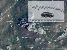 |
The browning of the Black HillsOver the last 15 years, Mountain Pine Beetles have killed large tracks of ponderosa pine across the Black Hills of South Dakota. Beetles thrive with continuous stands of dense trees, and decades of fire exclusion have led to that landscape and stand-level condition. That favorable habitat may help explain why the current epidemic of this native insect has been so severe. In this summer 2010 aerial photograph, the patchy structure of recent and older tree mortality shows up well around Harney... (read more) |
 |
The exceptional drought of 2011Across Texas, 2011 will long be remembered as the year that the trees died. After over a century of weather station data, 2011 saw record breaking drought across New Mexico, Texas, Oklahoma and Louisiana; but it was west Texas in particular, that suffered the greatest and most persistent loss of greenness from drought and the numerous associated fires. In this ForWarn image for late September 2011, there are centers of drought in and around Texas and farther to the Southeast centered on... (read more) |