Highlights
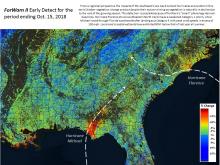 |
Hurricane Michael storms Florida's panhandleThe destructive impacts of Category 4 Hurricane Michael on the forests of northwest Florida were captured by ForWarn II's routinely produced Early Detect product one week after the event. The stark pattern of greatest damage in red and orange consists of a 50 km-wide swath that stretches from near the track of the hurricane's eye to the Apalachicola River which likely had reduced greenness from both wind damage and flooding. This damage to forests crosses the entire Florida panhandle into... (read more) |
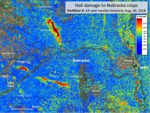 |
ForWarn II maps hail damage to Midwestern cropsForWarn's all-lands approach to monitoring provides valuable insights into crop damage caused by summer storms. In July and August of 2018, hail storms struck eastern Nebraska causing severe damage to corn and soy. Remote sensing provides an invaluable way to track severe weather's effect on agricultural production, especially when it can be delivered soon after the event. Most storm reports of hail, for example, do not result in detectable change, suggesting that they are of limited... (read more) |
 |
Hurricane Florence soaks the SouthHurricane impacts to forests can vary greatly depending on the qualities of the storm. Hurricane Florence stood out for its slow speed and heavy rainfall to the Carolinas, while Hurricane Michael, that crossed Florida's panhandle just a few weeks later in 2018, was a powerful wind-event that passed relatively quickly. ForWarn II's near-real-time capabilities reveal the initial storm effects, then in concert with higher resolution imagery and ancillary data assessments can discriminate among... (read more) |
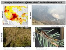 |
Assessing defoliation in the Boise National ForestForWarn’s ability to accurately map defoliation comes from the high temporal frequency of the source imagery (MODIS). With any change detection, multiple disturbances are often at work in the same landscape at the same time, so careful assessment requires consideration of other stressors or disturbances. In the Boise National Forest, defoliation from the spruce budworm and large wildfire have been recurring every year. Recently, a periodic eruption of the Douglas fir tussock moth has... (read more) |
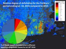 |
Monitoring the state of Rhode Island's forestsRemote sensing technologies provide an increasingly efficient way to monitor large tracts of forest canopy conditions in near-real-time and seasonally. Observational systems, such as ForWarn's MODIS-based product line, provide a continuous weekly stream of observational data that can be readily processed in ways that are useful for summary reports on changing forest conditions. Remote sensing approaches to regional monitoring are particularly powerful when they use consistent measures,... (read more) |
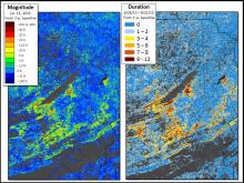 |
Tracking Gypsy Moth emergence and severity with magnitude and durationRemote sensing is adept at identifying and qualifying many forest disturbances, but there remains a substantial need to further quantify actual impacts in many cases. Traditionally, vegetation change-detection approaches, such as that used by ForWarn, identify and measure disturbance severity as the magnitude of change of some measure of reflected light between two dates or periods. ForWarn tracks the percent change in NDVI relative the prior year or years, with this index falling or rising... (read more) |
 |
Defoliation in NC's Roanoke River Bottomland ForestsThe Forest Tent Caterpillar (Malacosoma disstria) is a widespread native defoliator of deciduous forests in the Eastern US. While host trees differ regionally, the insect prefers sweet gum (Liquidambar styraciflua), tupelo gum, black gum (Nyssa spp.) and species of oak (Quercus spp.) in the bottomland forests of North Carolina's Coastal Plain. The larvae hatch in early spring as the tree buds swell, then larvae defoliate emerging and growing leaves in April and early May. After a few... (read more) |
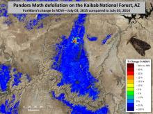 |
Pandora Moth defoliation returns to the KaibabThe Pandora Moth (Coloradia pandora) is a native defoliator of ponderosa, Jeffrey and lodgepole pine trees of the Western US. During most years, populations and defoliation is minor, but periodic outbreaks cause widespread defoliation (Speer and others 2001). The outbreak shown here in Arizona's Kaibab National Forest first caused significant defoliation in June-July of 2013 and defoliating caterpillars have now returned in 2015. One of the more peculiar aspects of outbreaks is that... (read more) |
 |
Mapping the urban phenological footprintUrban areas are renowned for their admixture of species and vegetation types that can change from one parcel to the next. Yards and woodland parks intermix with road medians--all of which may be dominated by an irregular mix of native and exotic trees, shrubs, herbs and grasses. In cities, the vegetation of nearly every block is compositionally complex. These species green up at different times and at different rates. Because of this, it can be difficult to decide when spring occurs... (read more) |
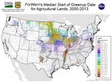 |
The typical start of greenup on agricultural landsUnderstanding the normal start of greenup for croplands is important because it provides a baseline to compare year to year conditions. The date of greenup for agricultural lands varies based on year-to-year climate factors, the unique responses of the specific crop or vegetation type planted, and farmers' management practices. For areas that need to be planted in the spring, wet late winters can delay planting. Cool springs can delay growth. Either can potentially influence seasonal growth... (read more) |